Aktualności
ARTYKUŁ ARCHIWALNY: "Sewerynówka - wodospad Zaskalnik" - Stanisław Zachwieja (ENGLISH)
Cudowny wodospad Zaskalnik oczami Stanisława Zachwiei. Serdecznie zapraszamy do sprawdzenia artykułu z numeru 2 (JESIEŃ 2012)
KUP WIOSENNY NUMER MAGAZYNU -------------------------->
BUY THE NEW ISSUE OF MAGAZINE--------------------------->
"Sewerynówka - wodospad Zaskalnik" - Stanisław Zachwieja
Do Doliny Sopotnickiego Potoku, w pobliżu zajazdu Czarda, gajówki i kościółka na Sewerynowie można łatwo dojść pieszo z centrum Uzdrowiska dwoma szlakami - jednym prowadzącym nad Osiedlem Mieszkaniowym "Połoniny" i drugim, biegnącym starą drogą przez Samorodny.
Nazwa Sewerynówka pochodzi od imienia Seweryna Fredry, brata Aleksandra, który w XIX wieku odbywał spacery inhalacyjne pośród dorodnego, także obecnie, drzewostanu świerków, jodeł i buków. Pisano wówczas: "Zarząd kąpieliska (od red. Uzdrowiska) zbudował na kształt świątyni dom, nazwany dla uczczenia czcigodnego, zakład szczawnickich kąpieli wielokrotnie udowodnionym zaufaniem darzącego hrabiego Seweryna Fredry - imieniem Sewerynka". Tego domu już nie ma. Ale pozostała nazwa Sewerynówka.
Ta część Szczawnicy przez długie lata opierała się nowoczesnej infrastrukturze, ale w końcu i tu powstały komfortowe pensjonaty i kwatery prywatne u miejscowych gospodarzy.
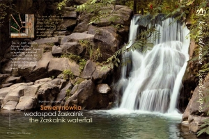
Wodospad Zaskalnik ma pięć metrów wysokości, a jego próg tworzą grube ławice odpornych na erozję piaskowców magurskich. Pod progiem zalegają ławice łupków i cienkie warstwy piaskowców. Podatne na erozję wytworzyły głęboki na dwa metry dół.
Opadająca z wielkim impetem woda wygląda bardzo malowniczo, zwłaszcza gdy wiruje różnorodnością kolorów w zależności od pory dnia i pory roku. Strefa wokół wodospadu i poniżej na odcinku 25 metrów potoku podlega prawnej ochronie.
Na ogół występowanie źródeł wód mineralnych kojarzone jest z centrum Uzdrowiska, zwłaszcza stokiem góry Bryjarka. Nic bardziej mylnego. Otóż występują one także w korycie Sopotnickiego Potoku w dolnej i górnej części wodospadu Zaskalnik.
Znane i opisywane w literaturze hydrologicznej dzikie źródło Barbara znajduje się około 100 metrów poniżej wodospadu. Jego mineralizacja osiąga ponad 150 mg/dm3. Natrafić też można na inne źródło znajdujące się około 150 metrów powyżej wodospadu w bliskości zajazdu Czarda, gdzie po trudach wędrowania można odpocząć, spróbować regionalnych potraw i na- pić się dobrej kawy, a przy odrobinie szczęścia posłuchać muzyki góralskiej i czardaszy w wykonaniu kapeli góralskiej lub cygańskiej.
Po kilku minutach marszu natrafiamy na stojącą tuż przy drodze leśniczówkę przy niebieskim szlaku na Przehybę. Dalej ukazuje się nam niewielki kościółek w stylu góralskim. Latem odprawiane są w nim msze święte.
Cały artykuł dostępny w 2 numerze naszego magazynu, który cały czas jest dostępny w naszym sklepie internetowym.
Serdecznie zapraszamy.
-----------------------------------------------------------------------------------------------------------------------------------------------------------------
The Valley of the Sopotnicki Stream, near the Czarda Inn, the forester’s lodge, and the church in Sewerynów, is easily ac- cessible for walkers along two routes: one leading over the Połoniny residential set- tlement, and the other along the old road through Samorodny.
The name Sewerynówka is derived from that of Count Seweryn Fredro, brother of the famo- us Aleksander, who in the 19th century held “inhalation perambulations” among the – still preserved – magnificent spruces, firs, and be- eches. To quote his contemporaries: “the ma- nagement of the spa built a house to the sha- pe of a temple, and named it Sewerynka, to revere the honourable Count Seweryn Fredro, who has repeatedly proved his trust for the Szczawnica spa”. The house is gone, yet the name of Sewerynówka has remained.
This part of Szczawnica has long resisted modern infrastructure, yet finally comfortable boarding houses and bed-and-breakfasts have also sprung up here.
The Zaskalnik waterfall is 5 m (17 ft) high, and its lip is composed of thick shelves of Magura sandstone, resistant to erosion. Lying below are shoals of shale and thin layers of erosion- prone sandstone. They form a cauldron that is 2 m (7 ft) deep.
The water looks very picturesque, falling with great force, especially when it whirls with a variety of colours depending on the time of the day and the season. The zone around the waterfall, and the first 25 m (85 ft) down the stream, are legally protected.
Usually, the presence of mineral water sources is associated with the centre of the spa, especially the slope of Mount Bryjarka. However, no- thing could be further from the truth. They are also present in the bed of the Sopotnicki stream, below and above the Zaskalnik waterfall.
Known and described in hydrological literatu- re, the wild Barbara spring, with mineralisation exceeding 150 mg/dm3, is situated about 100 m (330 ft) below the waterfall. There is also another source – approximately 150 m (500 ft) above the waterfall, very close to the Czarda Inn, where – when tired of walking – you can relax, try regio- nal dishes, and have a decent cup of coffee. With a little luck, you can listen to Highlander music and Csárdáses performed by Highlander and Gypsy bands.
Walking along the blue waymarked trail, we reach the forester’s lodge situated just by the road to Przehyba. Standing somewhat further is a small church in Highland style. Masses are celebrated here in summer.
You can find more in the the latest issue of "Polski Region Pieniny" magazine. Enjoy!
